DJI
Agriculture
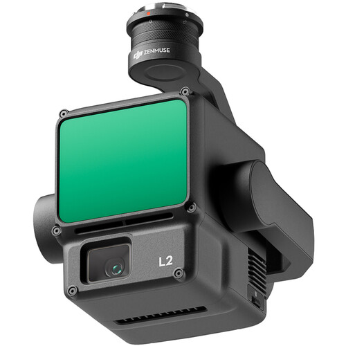
DJI Zenmuse L2
$8,800.00
Volume Pricing — Buy more, save more
| Qty | Unit Price | Savings |
|---|---|---|
| 5 ~ 9 | $8,360.00 | -5% |
| 10 ~ 19 | $7,920.00 | -10% |
| 20 ~ 49 | $7,480.00 | -15% |
| 50+ | $7,040.00 | -20% |
Offering ultra-fine precision to professional applicati […]
Key Features
Flight Routes
five returns
Offering ultra-fine precision to professional applications, the DJI Zenmuse L2 RGB/LiDAR Payload with Enterprise Care Basic incorporates both frame LiDAR and 4/3 CMOS RGB cameras with a 3-axis gimbal. This setup is ideal for industrial drones, such as the Matrice, and in various professions, such as land surveying/mapping, forestry management, and electrical inspections. The LiDAR camera is coupled with a high-accuracy IMU system, so you can capture finely detailed point clouds and precision drone positioning data. The RGB camera offers 20MP standard images and videos, along with true color to LiDAR point clouds. Both can be used with automated flight routes and other optional DJI technologies, such as DJI Terra and RTK equipment. As this payload is essential to mission-critical flights, the included Enterprise Care Basic offers easy replacement and technical support when needed.
LiDAR Camera
Compared to the previous L1 model, the L2 upgrades the precision, detail, range, penetration, and speed of point cloud mapping.
- Precision: When combined with your drone's GPS and the L2's IMU system, the L2 can achieve a vertical accuracy of 1.6" and a horizontal accuracy of 2".
- Detail and Penetration: With a smaller spot size of 1.6x4.7", Digital Elevation Models (DEMs) are more accurate, the L2 can detect smaller objects and penetrate denser vegetation.
- Range: Also applicable to the RGB camera, the effective range of the L2 is roughly one square mile in a single flight.
- Speed: In single and multiple return modes, more point cloud data can be recorded at a given time with the L2's ability to capture 240,000 points per second
- Two Scanning Modes: Use Repetitive Scanning mode for more uniform and accurate point clouds with high precision. Non-Repetitive mode is geared for deeper penetration of foliage for more accurate structural mapping
RGB Camera
Use this 20MP camera to capture standard images, videos, and mapping in visible light, or add true color to point cloud details. The pixel size has been enlarged to 3.3 μm for more improved lowlight performance, and overall speed is fast with a 0.7-second minimum interval between photos.
IMU System
The IMU system utilized within the L2 delivers improved environmental adaptability and highly accurate absolute position, speed, and attitude data. In real-time, yaw and pitch/roll accuracy are 0.2° and 0.05° respectively, and 0.05° and 0.025° during post-processing.
Operational Enhancements
- Flight Routes: Supports Waypoint, Area, and Linear route types for handling tasks in a variety of environments.
- Liveview Modes: The three modes available for liveview during flight are RGB, point cloud, and a side-by-side of the two. When in point cloud mode, you can access its own coloring modes in real-time, reflectivity, height, distance, and RGB. A laser rangefinder feature can also be engaged to view the distance between the LiDAR module and your subject.
- Point Cloud Model Playback and Merging: After the operation, the 3D point cloud model can be viewed directly in the album, and multiple flight models can be merged on-site to generate a full picture of a given location.
- Auto-Generated Task Quality Report: Use the DJI Pilot 2 app after data collection to automatically generate a Task Quality Report so that operators can check results in real-time and on-site, making fieldwork more responsive and worry-free.
- PPK Solution: In complex operational environments, set up optional RTK base stations beforehand to preemptively avoid the loss of RTK data due to interference, video transmission disconnection, or other issues. Afterward, import files into DJI Terra to use the PPK (Post-Processing Kinematic) process to rebuild high-precision models.
- One-Click Processing with DJI Terra: Achieve efficient and reliable one-stop post-processing when importing point cloud data into DJI Terra. Generate a standard-format 3D point cloud model with just a click after point cloud trajectory calculation and accuracy optimization. Upon ground point classification, using Ground Point Type, a DEM can be created. Point cloud quality can then be analyzed with the Accuracy Control and Check function.
DJI Care Enterprise Basic
This protection plan offers multiple benefits when replacing and servicing the Zenmuse L2. This specific plan runs for one year and provides up to two replacements at a low replacement fee and the DJI Care Enterprise Basic Renew extended service plan. The plan covers damage from user error, signal interference, collision, water damage, and drop damage. When submitting a replacement request, DJI will also provide free delivery.
Additional Features
- Supports five returns to help capture more ground points beneath foliage
- Mechanical shutter with a 200,000-operation lifespan
- Ready to shoot as soon as it is powered on with no warmup needed
- Detection range of 820' at 10% reflectivity, 100 klx, or 1476' at 50% reflectivity, 0 klx