DJI
Surveying
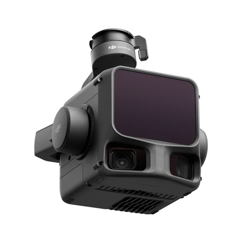
DJI Zenmuse L3 LiDAR Sensor
$17,400.00
Aerial LiDAR sensor with 500m detection range, 100MP RGB camera, up to 2M pulses/sec, 4/3 CMOS sensor, IP54 rating, compatible with DJI Matrice 400 for survey, mapping, and mining applications.
Key Features
500m Detection Range
100MP RGB Camera
2M Pulses/sec
IP54 Rating
4 Returns
Multiple Scanning Modes
Class 1 Laser
DJI Zenmuse L3 LiDAR Sensor
Next-generation aerial LiDAR and imaging system integrating a high-performance LiDAR module with extended detection range, powerful RGB camera, high-precision IMU, and 3-axis stabilized gimbal in a lightweight design.
Key Applications
- Topographic Survey
- Earthwork
- Geological Disaster Investigation
- Engineering Survey
- Forestry Management
- Electricity
- Mining Survey
- Emergency Survey
Key Features
- Point Cloud Density: Up to 5+ laser returns for vegetation penetration
- Extended Detection Range: Up to 500m on low-reflectivity targets
- Accuracy: Vertical 2-3 cm, Horizontal 3-4 cm
- Maximum Range: 950m at 100 kHz, 2000m at 80% reflectivity
- High Pulse Rate: Up to 2 million pulses per second
- Multiple Scanning Modes: Linear, Star-Shaped, Non-Repetitive
LiDAR Specifications
- Laser Wavelength: 1535 nm
- Ranging Accuracy: ±10 mm absolute, <5 mm repeatability
- Laser Safety: Class 1
- Pulse Rate: 100/350/1000/2000 kHz
- Number of Returns: Up to 16 returns
RGB Camera Specifications
- Sensor: 4/3 CMOS
- Photo Resolution: 100 MP (12288×8192) or 25 MP (6144×4096)
- Video: 4K@30fps, FHD@30fps
- Lens: 28mm equivalent, f/2.0-f/11
- GSD: 3 cm average at 300m altitude
Technical Specs
- Weight: 1.60 kg (without gimbal connector)
- Dimensions: 192×162×202 mm
- Power: 64 W typical, 100 W max
- Ingress Protection: IP54
- Operating Temperature: -20° to 50° C
- Compatibility: DJI Matrice 400
Software Ecosystem
- Data Collection: DJI Pilot 2
- Data Processing: DJI Terra
- Data Application: DJI Modify
- Cloud: DJI FlightHub 2
- Export Formats: PNTS/LAS/LAZ/PLY/PCD/S3MB
SKU: CP.EN.00000703.01